
At your request, we have prepared a list of recommended trips in Amirim and the surrounding area
The unique moshav of Amirim, located in the Upper Galilee, is a pilgrimage site for countless vacationers and travelers, and this is no coincidence. Besides the fascinating view seen from the moshav, there is no shortage of various hiking trails in Amirim (for example, the observation point and hidden paths), and nearby, a variety of ideal trip spots await for all seasons—so that among others, you can enjoy the Parod Waterfall, the Nahal Amud Nature Reserve, Elijah’s Chair in Nahal Meron, the Nahal Tzalmon trail, Mount Meron, the ancient synagogue in Peki’in, and more.
From here, you can both come to vacation in high-quality cabins and along the way get to know new places or, alternatively, return to beloved spots that only the Galilee region knows how to offer.
Enjoy!
Moshav Amirim

• A tour of the village woodland paths, the Hidden Path, the Cave Path.
• A sculpture garden featuring artists from Israel and around the world, sponsored by the Israel Museum. The sculptures are scattered in a natural grove of oak and terebinth trees. The garden is lit at night.
• Scenic lookouts over the Sea of Galilee – two main viewpoints: ‘Mitzpe Nof Menachem’ + a memorial with a fighter jet (at the eastern end of HaOranim Street) and ‘Mitzpe Kinneret’ (on Mitzpe Kinneret Street).
• Swimming pool in the summer
• Restaurants, unique shops, art galleries
Shefer Spring (Ein Ramiel-HaRomela)
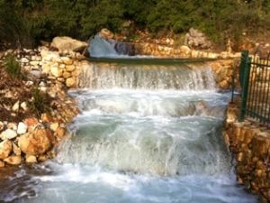 2 km from ‘Or Bereshit’ Cabins, Amirim
A spring bursting from the mountain near a rock adjacent to Moshav Shefer. The spring water flows through an organized channel and falls with great force into a well-maintained artificial pool that collects the spring water located in Moshav Shefer. From the pool, the water flows through channels and small waterfalls within the moshav area. Further on, they form the Parod Stream.
It is recommended to visit the spring and the stream during the warm winter or spring days.
Nahal Parod and Parod Waterfall

2.5 km from ‘Or Bereshit’ Cabins, Amirim
Arrival Map >> A stream flowing in an interesting channel within a grove of oak, terebinth, and carob trees, and even creates two high waterfalls (about 3-4 meters) during the rainy season. Even when there is no water, it is a beautiful spot.
Walk along the dirt paths beside the stream (which flows only after heavy rains). At the beginning of the path are the remains of an aqueduct and a fine trough, two “Tombs of the Righteous” on the eastern bank, in small white buildings with blue domes in memory of Nehemiah HaAmsoni and Ishmael Ba’al HaBaraitot. Further on, there are ancient burial caves. In this area, prickly pear bushes and olive trees remain from the orchards of the village of Faradiya, which preserves the ancient name Parod—a Jewish settlement mentioned in the Babylonian Talmud.
You can reach free parking in nature with your car before the entrance to Kibbutz Parod.
Nahal Amud Nature Reserve
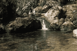 5 km north of the Or Bereshit cabin in Amirim
A trip from a different angle in the Nahal Amud Reserve, for more details >>
Orientation map of the reserve >> To reach Nahal Amud from the south: drive north from Hananya Junction on Road 866, pass Amirim and Kfar Shamai for about two kilometers, turn right at the Nahal Amud signs, drive on a dirt road for another kilometer and a half and reach the parking lot.
At the start of the trail, you will find an information station, restrooms, and a snack bar. The trail begins on the wide path marked in red toward the Ein Tina police station. The police station is an abandoned building riddled with bullet holes from the days of the Arab Revolt. Here you can look out over Safed, situated across Nahal Amud. We will continue down the path to Ein Yakum; this is the southern bank of Nahal Meron. Along the path, we will notice Judas trees with heart-shaped leaves. From there, we will continue down the stream until we reach Ein Yakim. The spring flows all year round, and beside it grows a walnut tree that invites you to sit in its shade.
From here, continue until the fork in the paths; if you turn right, you reach the aqueduct and the remains of the flour mill. The storage pool was used to irrigate the adjacent plots; at the foot of the pool, water bursts from a small fountain, and this is the time to sit and rest. From there, we will continue to the restored orchard and see the reconstruction of the irrigation system for the fruit trees planted there. From there, we will reach the farmhouse, which has two stone arches at its front. If we stop at the edge of the orchards, we can look out toward the magnificent views of the reserve.
Entry fee required, trip duration about 3 hours.
For details: Information station 04-6999984
Upper Nahal Meron and Elijah’s Chair
6.5 km from ‘Or Bereshit’ Cabins, Amirim
Arrival Map >> The start and end of the trail is on Road No. 866, which connects Hananya Junction with Meron Junction, about 3 km north of the entrance to Moshav Kfar-Shamai. The trail begins at the large bend of Road No. 866, south of Moshav Meron. At the meeting of Nahal Meron and its tributary Nahal Bar-Yochai, you can see the remains of a flour mill that operated in the past by utilizing the strong spring flow in Nahal Meron. At this point, after the rains, Ein Bar-Yochai and Ein Meron flow, surrounded by Mediterranean woodland.
Ein Zevad – in the shade of an oak tree, serves as a water source for the animals in the area. This is a pleasant corner for rest, and the nearby field is abundant with spectacular spring blooms.
Toward the end of the descent, you pass an impressive rock pillar; this is Elijah’s Chair. Legend has it that in the end of days, Elijah the Prophet will sit on the chair and blow the shofar to herald the coming of the Messiah. Shortly after Elijah’s Chair, the path passes through the archaeological site of Horvat Shema, where many remains are found, including a huge and impressive mausoleum, remains of an ancient synagogue, burial caves, and an olive press. From Horvat Shema, the path descends on a comfortable dirt road and reaches Ein Meron, which we passed at the beginning of the trail. From here, it is a short way back to the starting point.
Nahal Tzalmon
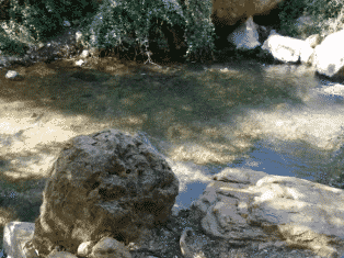
11 km from ‘Or Bereshit’ Cabins, Amirim
Start from a gravel parking lot (there is signage) on Road 804 connecting Rama Junction to Arraba. The trees you see on the sides of the road belong to charcoal-making plants operating in the area.
At the beginning, you descend the path; every few dozen meters there are small pools and waterfalls, a rock slide between two adjacent pools, shaded spots for picnics, and places where you can simply walk in the water. On the way, there is also a burial cave, carob trees, terebinths, oaks, raspberry bushes, oleanders, and plenty of mint and peppermint bushes. The stream continues to the Sea of Galilee (emptying in the area of Kibbutz Ginosar). Return via the road where the vehicles are located.
Mount Koter
13 km from ‘Or Bereshit’ Cabins, Amirim
Mount Koter near Mount Meron, on the road leading to Safed. On its southern slope lies the settlement of Kadita, an ecological settlement—studded with olive trees, crumbling ancient terraces, and remains of orchards.
The burial site of Rabbi Tarfon is located on a hill and sheltered in the shade of a large terebinth tree on the outskirts of the settlement of Kadita, which in its past was an Arab village. (“The day is short and the work is great, and the laborers are lazy and the reward is much and the Master of the house is urgent”… remember? Rabbi Tarfon said that).
The road to Mount Koter is planted with grape vineyards. The place sits at the source of Nahal Amud, overlooking a small valley and the ridges of Mount Safed on the edge of the Dalton Plateau. Reach it from Road 89 between Meron Junction and Ein Zeitim Junction.
Akbara Rock Nature Reserve
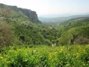
18.5 km from ‘Or Bereshit’ Cabins, Amirim
The reserve is located on the eastern side of Nahal Akbara, above the village of Akbara, between Ein-Akavia in the north and the Ein-Sela area in the south. Akbara Rock is the highest cliff in the Galilee (130 m); the cliff is an Eocene limestone cliff. In Nahal Akbara, there are many orchards of almond and olive trees and about 150 caves. Birds of prey nest in this area. At the foot of the cliff are Ein Akavia (within the reserve), Ein Yanai, and Ein-Sela, and further down Nahal Akbara, Ein-Kahal flows.
Entrance is from Road No. 8900 (the old road from Rosh Pina to Safed); a blue-marked pedestrian path descends through Nahal Akbara almost along its entire length, through the village of Akbara and the southwestern edge of the Akbara cliff, toward Road No. 65, about a km east of Nahal Amud Junction. Good views of the reserve can be seen from the Akbara Bridge on Road No. 89 (Elifelet – Safed Interchange), and from Road No. 85 east of Nahal Amud Junction.
Mount Meron

24.2 km from ‘Or Bereshit’ Cabins, Amirim
Three lookouts on the Summit Trail at Mount Meron, for more details >>
Access to Mount Meron is from the north, via Road No. 89. At Meron Junction, continue straight on Road No. 89, through Hiram Junction, and after 2.5 km reach the access turnoff to Mount Meron.
The trail begins and ends at the Summit Trail parking lot, a circular trip of about one to two hours, south of the summit of Mount Meron. From this point, the Summit Trail departs, encircling the peak of Mount Meron—the highest of the Galilee mountains (1208 m above sea level). The path passes through Mediterranean woodland of common oak and Boissier oak, and reaches the Safed Lookout, from which there is a view eastward to the Safed area and the Dalton Plateau. The continuation of the path encircles the peak from the north, through the Lebanon Lookout. The path continues past an ancient winepress and reaches a junction of paths with the “Mountain Trail,” marked in black, which descends from here to the Mount Meron Field School. Do not descend this path, but continue on the Summit Trail, cross a dirt road used by the base, and after it reach the Mountain Lookout—a view toward the western slopes of the Meron Mountains and the Western Galilee.
Shortly after the Mountain Lookout, the path reaches a road junction, from where we will continue to the parking lot.
Peki’in


Just stroll through the alleys, visit the ancient synagogue, splash your feet in the spring, enter the Rashbi Cave, buy soap from “Grandma Jamila” and special Druze foods at the stalls and shops around the Spring Square. You can also pop into the “Al-Zaitun” olive press, the sculpture gallery of Harubi Fadul (who, if the mood strikes him, will also demonstrate playing the oud for you), or the Orchard Hive – a visitor center about honey with small, fresh, and delightful meals. Photography enthusiasts will celebrate in the picturesque town, and if you join a guided tour – your enjoyment (and general education) will be doubled.
Wishing you a fun and pleasant vacation:
Debby and Shalom – 054-5747691
Or Bereshit – Cabins in Amirim
A perfect experience for loving couples..